Ed. Note: We know that most of you are doing your best to avoid busy places during the coronavirus pandemic–we’re doing the same thing–and that many of the places below are actively discouraging visitors to help slow the spread of the virus. So that leaves daydreaming about trails to come. We hope you enjoy this collection of hikes and find a few things on here to add to your tick list, because we will be getting back out there soon enough. In the meantime, stay safe.

["Dog Mountain Trail in Washington"] by Landscapes in The is licensed under CC PDM 1.0
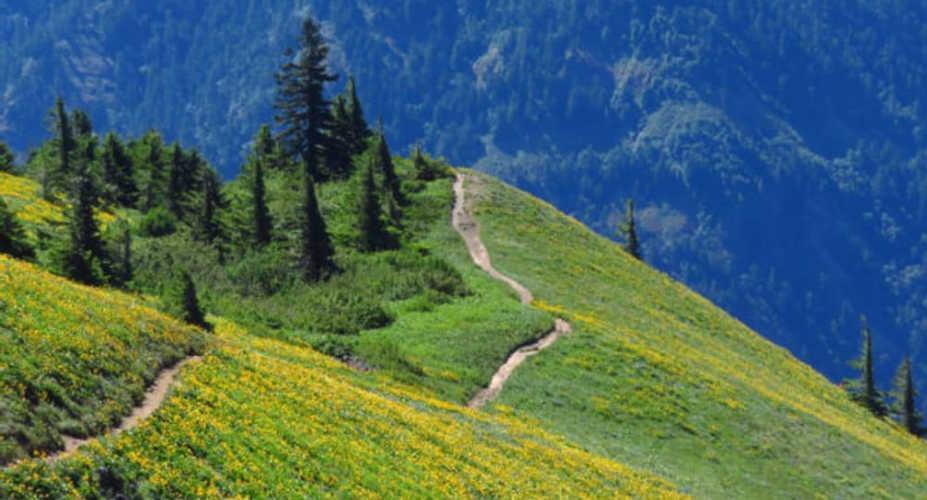
Dog Mountain, Columbia River Gorge, WA
Climb through bright yellow fields of balsamroot and panoramic views over the Columbia River Gorge to Mt. Hood on this 6-mile out-and-back from the Dog Mountain trailhead. Start with a .5-mile climb through the conifers to a junction, where you turn right onto the Dog Mountain trail. Here the views over the Columbia begin. Scattered at first, they open up 1 mile past the junction at the first viewpoint. Take a breather to admire 1,907-foot Wind Mountain and the top of Dog Mountain, as well as the broad Columbia River Gorge below, then brace yourself for the rest of the climb. Half a mile from the first viewpoint bear right at another trail junction, then climb one more mile to the top of the meadow and panoramic views over bright fields of wildflowers to the mountains and river gorge beyond.
Permit Required for weekends between April 18 and June 14, and a NW Forest Pass or day pass required for parking Contact Columbia River Gorge National Scenic Area

Image by joedecruyenaere is licensed under CC BY-SA 2.0
Siphon Draw Trail, Lost Dutchman State Park, AZ
Spring in Arizona’s Superstition Mountains is surprisingly colorful. Brittlebrush, chuparosa, globe mallow and poppies all compete for attention as spring sweeps in. For some of the best flowers in the park follow the Siphon Draw Trail, winding into a canyon over 4 miles round-trip. The trail ends at a slickrock basin, home to a rare waterfall. Taking a moment to look up from the rainbow of wildflowers nets you views of the Flatiron massif’s sheer cliffs, jagged Superstition Mountain and the Phoenix Metro Area.
Permit Park entrance fee $7 per vehicle Contact Lost Dutchman State Park

"COD Hosts Free Prairie Tour 2016 21" by COD Newsroom is licensed under CC BY 2.0
Fox Creek Trail, Tallgrass Prairie National Preserve, KS
Wander through restored creek bottom prairie, six-foot grasses, and more than 30 species of wildflowers on this 6-mile out-and-back. Start by going left from the parking lot on the Bottomland Nature Trail, branching off at mile .2 to follow Fox Creek. The Fox Creek trail winds along the creek until it meets the Z-bar Spur trail; this makes a good turnaround point. Keep your eyes peeled for violet wood sorrel, blue wild indigo, prickly pear, and prairie wild rose between the grasses.
Permit none Contact Tallgrass Prairie National Preserve

"lupines1" by brx0 is licensed under CC BY-SA 2.0
Cone Peak, Willamette National Forest, OR
Almost all of the western Cascade Range’s 300+ species of wildflowers can be found in Cone Peak’s meadows. The bloom peaks in June and July but can start much earlier in low snow years, crowding together fireweed, lupine, Indian paintbrushes, penstemons, scarlet gilia, coneflowers, mountain cat’s ear, and wooly sunflowers. Start from the trailhead near Tombstone Pass on highway U.S. 20. The Cone Peak Trail starts just south of the parking lot; follow a dirt road south for less than a quarter mile until you reach an unsigned path dropping off to the left. The trail descends gradually for .5 mile before crossing the highway, resuming the climb 50 feet to the left along the road. From there the switchbacks begin, climbing 3 miles to the open meadows of wildflowers and views of forested Iron and Echo Mountains.
Permit Northwest Forest Pass required for parking Contact Willamette National Forest

"Ligusticum porteri - Osha" by theforestprimeval is licensed under CC BY-SA 2.0
Alpine Pond Nature Trail, Cedar Breaks National Monument, UT
The Wildflower Festival here doesn’t start until July, but the blooms aren’t waiting: Columbine, globemallow, thistle, yucca, and mariposa lilies have already started the show. Get a glimpse of more than 250 species on the Alpine Pond Nature Trail. The 2-mile figure-eight has more than just flowers to offer, though. The lower trail has views over the orange- and white-striped badlands, while the upper trail winds through meadows, mixed spruce, fir, and aspen forest, and ancient volcanic deposits.
Permit Park entrance fee, $7 per person Contact Cedar Breaks National Monument

"Tomales Point, Point Reyes" by Franco Folini is licensed under CC BY-SA 2.0
Tomales Point Trail, Point Reyes National Seashore, CA
Salt air mingles with the scent of lupine and California poppies on this 9.5-mile out-and-back oceanside hike. Many hikers turn around when the well-maintained trail ends at mile 3, but for those who don’t mind a bit of bushwhacking the views from the point itself are well worth it. Keep an eye out for Tule elk in the gulch below Windy Gap (mile 2) before heading back into the orange waves of California poppy. Lupines, irises and monkeyflowers offer spots of color in the meadows, while below the land drops away to the Pacific. Fog and wind, common on this stretch of coast, can limit visibility, so make sure you’re comfortable navigating by map or device and check the forecast.
Permit none Contact Point Reyes National Seashore

"Wood Lily (Lilium philadelphicum)" by wackybadger is licensed under CC BY-SA 2.0
Gem Lake, Rocky Mountain National Park, CO
Mountain views, alpine lakes, and wildflower meadows—this hike has it all. From the Lumpy Ridge Trailhead north of Estes Park, take the Gem Lake Trail heading right. The first part of the path winds through a narrow canyon and past the corner of a historic ranch before starting to climb. As you gain elevation the views open up, spreading from Estes Park to Longs Peak and the continental divide. Keep an eye out for woodlilies and purple beardless sidebells penstemons on either side of the trail. The last stretch before the lake clambers up stone steps cut into the mountain itself before dropping to Gem Lake. Check tiny pockets in the granite cliffs surrounding the lake for the rare pink flowers of James’ telesonix. Retrace your steps to complete the 3.5-mile out-and-back.
Permit Park entrance fee, $25 per vehicle Contact Rocky Mountain National Park

Image by Jim Sorbie is licensed under CC BY 2.0
Porter’s Creek Trail, Great Smoky Mountains National Park, TN
Follow Porter’s Creek through old-growth forest and a fantastic wildflower show on this 4-mile out-and-back. Unlike the high-mountain meadows, the flowers here peak in April. There are three bridges in the first 1.6 miles, crossing in and out of small breaks in the forest cover. The real show, though, is under the trees. It isn’t a rainbow of colors that makes this particular spring bloom spectacular; instead trillium and tiny fringed phacelia cover the forest floor in delicate white blooms, standing out brightly against the deep green backdrop. Turn around at Fern Branch Falls, just up the hill left of the trail’s end.
Permit none Contact Great Smoky Mountains National Park

"Chickweed" by hedera.baltica is licensed under CC BY-SA 2.0
Pocket Loop Trail, Crockford-Pigeon Mountain Wildlife Management Area, GA
Start on the boardwalks of the Shirley Miller Wildflower Trail before breaking off on the 9-mile Pocket Loop for even more spring color. Follow blue trail markers to the highest hikeable point on Pigeon Mountain, with views out across rolling hills and farmland before summer’s foliage fills in around late May. The loop gains about 1,800 feet in elevation and is fairly rugged. The best wildflowers come near the beginning, where Virginia bluebell, star chickweed, wild hydrangea, wood poppy, and Dutchman’s breeches crowd the trail. The path can become hard to navigate after rainstorms, when parts of the trail transform into small creeks.
Permit Georgia Lands Pass ($30 per year, day passes available) Contact Crockford-Pigeon Mountain WMA

"Gull Picnic" by Matt Tillett is licensed under CC BY 2.0
Bar Island, Acadia National Park, ME
This 1.9-mile loop of an island in Acadia National Park comes with a time crunch; the trail is only accessible via a gravel bar from the town of Bar Harbor, and the gravel bar is only exposed at low tide. Average tide swings still leave you with three hours to finish the loop. That’s plenty of time to poke through tidepools, hike through the island’s crown of forest, and linger in the best spring spot on the hike—a meadow hidden in the island interior that fills with purple lupines every year.
Permit none Contact Acadia National Park
Written by Kristin Smith for Backpacker and legally licensed through the Matcha publisher network. Please direct all licensing questions to legal@getmatcha.com.


